Since January 12, 2020, the Taal volcano has been observed generating a tall ash column that has been measured to reach up to 15 kilometers. This has affected the areas of CALABARZON, parts of Metro Manila, and other parts of Southern Luzon. Amidst the eruption of Taal, Waze, the community-driven navigation app, together with the Department of Transporation, CNN Philippines, and DZMM (630 AM) Radyo Patrol, have been working on a new crisis response feature.
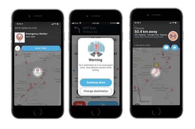
The companies have been working together in order to keep motorists updated with the happenings in the vicinity of Taal Volcano. Waze's new feature updates users about road closures due to the volcano’s activity, aiding to streamline the process of evacuation in case a crisis occurs. The map comes with the added bonus of showing locations of evacuation centers, emergency shelters, and donation locations. Having this critical information can easily lead users to safe areas in the event of an eruption.
The application also informs the user if they are approaching a dangerous area. It also applies when the user wants to navigate to a location within the 14-km danger zone set by the National Disaster Risk Reduction and Management Council (NDRRMC). The Waze Crisis Response team has set up the area as an evacuation zone on the map, as well. A notification will pop up to warn if the user will navigate to a destination within the exclusion zone.
An added bonus to the new feature is that it can aid with relief operations. It works by keeping track of official donation compounds around the user. To find these collections and distribution locations all the user has to do is type “Donate” into the application’s search bar and it will automatically show where the nearest area in which the user can drop off their goods.
Latest News
-

Will the New Mitsubishi ASX Make Its Way to the Philippines? / News
The newly updated Mitsubishi ASX has debuted in Europe, featuring enhanced technology and design.
-
The Mazda EZ-6 might be the spiritual successor of the Mazda 6 Sedan / News
Unveiled in China, the all-new Mazda EZ-6 is a rear-wheel drive sedan available as an EV or a plug-in hybrid vehicle.
-
Mitsubishi breaks the speed limit on sales records in FY2023! / News
Mitsubishi Motors Philippines Corporation reports record-breaking sales of 81,743 vehicles in FY2023


Popular Articles
-
Cheapest cars under P700,000 in the Philippines
Aug 25, 2023
-
First car or next car, the Ford EcoSport is a tough package to beat
Jun 18, 2021
-
Car Maintenance checklist and guide – here’s everything you need to know
Earl Lee · Jan 12, 2021
-
Most fuel efficient family cars in the Philippines
Bryan Aaron Rivera · Nov 27, 2020
-
2021 Geely Okavango — Everything you need to know
Joey Deriquito · Nov 19, 2020
-
Family cars in the Philippines with the biggest trunks
Sep 20, 2023
-
Head to head: Toyota Rush vs. Suzuki XL7
Joey Deriquito · Oct 28, 2020
-
Why oil changes are important for your car
Earl Lee · Nov 10, 2020
-
2021 Kia Stonic — What you need to know about it
Joey Deriquito · Oct 16, 2020
-
Top 7 tips for buying a used car in the Philippines
Joey Deriquito · Nov 26, 2020