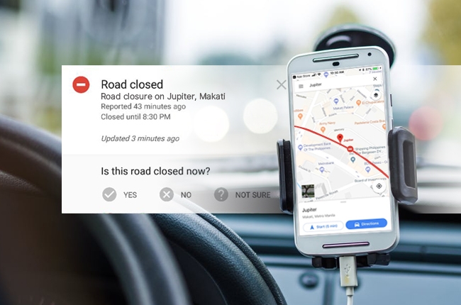
A few days ago, Google Maps users noticed a new feature on the application, which stirred up the curiosity of some people. As such, Google just recently confirmed that yes, it’s adopting Waze’s incident reporting feature and it has been live for several months on Android.
Just like in Waze, Google Maps now comes with road work marks and accident report time. To keep the data as updated as possible, users can also key in their answers whether the slowdown still affects the specific route by choosing from three options: yes, no, and not sure.

This tool is a great way to gather a crowd-sourced information for more accurate data among its users. However, there’s no exact detail if the feature will be permanent and available to all Android users, as well as iPhone users, or if it’s just up for testing, so let’s anticipate the company’s next update.
Both apps might be owned by the same company but these two actually have a distinguished purpose. Waze is most likely a driver-centered app, while Google Maps is used commonly for local business information and restaurant recommendations. If the incident reporting feature will be officially put out on Google Maps, then it’ll be a more useful app than ever.
Aside from that, Google’s in-house start-up incubator, Area 120, is reportedly developing an app dubbed as “Pigeon”. This app lets users report delays and accidents on New York City subway system, so it’s basically a transit version of Waze. Let’s hope that these projects would push through and wish that it would also have a version for our rail transit system in the future.
Latest News
-
Geely’s EX2 EV headed to Australia — is a Philippine launch possible? / News
The Geely EX2 is confirmed to go on sale in Australia in 2026. Could a launch in the Philippines also be on the cards?
-
Hyundai Motor Philippines is the FIFA Futsal Women's Teams' official mobility partner / News
Hyundai Motor Philippines strengthened its partnership with FIFA through its support of the FIFA Futsal Women's Teams.
-
Kia Philippines backs EJ Obiena as Atletang Ayala continues championing Filipino athletes / News
Kia Philippines strengthens its support for EJ Obiena, backing the Olympian with dedicated mobility at home and abroad.
Popular Articles
-
Electric Vehicles in the Philippines for under P1 million
Jerome Tresvalles · Aug 19, 2025
-
Top 3 Cars For Every Lifestyle—What Cars Are Right For You? | Behind a Desk
Caco Tirona · Apr 24, 2024
-
5 Tips to Maximize Fuel Efficiency
Jerome Tresvalles · Sep 09, 2024
-
Five driving habits that are draining your fuel tank
Jerome Tresvalles · Jun 24, 2025
-
Can engine braking harm your engine?
Jerome Tresvalles · Sep 11, 2025
-
Do electric cars even need maintenance?
Jerome Tresvalles · Oct 23, 2024
-
Best vehicles for an active outdoor lifestyle
Shaynah Miranda · Jul 25, 2024
-
How to drive different types of vehicle transmissions
May 23, 2024
-
5 easy ways to keep your car interior clean
Allysa Mae Zulueta · Nov 15, 2021
-
How to survive Metro Manila traffic
Earl Lee · Aug 16, 2022


